
GPU Ocean
A GPU-accelerated simulation framework for running large ensembles of simplified ocean models for real-world domains.

To enhance the precision of these simulations, assimilating measured data, such as real-time oceanographic observations, becomes indispensable in refining models and improving the reliability of predictions. Unfortunately, operational ocean forecasting models are very complex, and are, due to their computational expense, typically run as single deterministic simulations at intervals, resulting in a lack of information about forecast uncertainties. This is crucial, particularly for applications like search-and-rescue operations at sea, where uncertainties play a significant role, given the limited number of ocean observations relative to its vast size.
Years ago, in collaboration with the Norwegian Meteorological Institute, we initiated the development of GPU-based simulators for solving barotropic dynamics described by the shallow-water equations. The collaborative GPU Ocean project (with NTNU as educational partner) resulted in the creation of methods and open-source software for rapidly simulating ensembles of thousands of simplified ocean-circulation models, with operational use on a daily basis; see, e.g., Holm (2020). Running large ensembles of simultaneous model simulations with varying forcing and initial conditions, nested within operational 3D models, enhances our ability to generate robust uncertainty estimates and glean insights into dominant physical processes. By selecting simulations consistent with limited observations, we can achieve more accurate predictions of ocean drift.

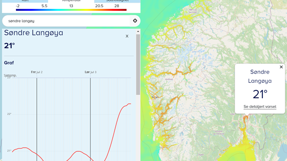
Together with the Institute of Marine Research and the Norwegian Meteorological Institute (with NTNU as educational partner), we have started to prepare for the next generation ocean forecast services covering improved technological and methodological solutions for receiving user observations, forecast model subsetting, data assimilation, and finally displaying tailored forecasts to users. The prospective operational service targets both recreational and professional users. The first version of the webservice havvarsel.no is launched, which currently forecasts temperature and salinity in the upper ocean layer surrounding Norway. Novel methods are applied to demonstrator cases from search-and-rescue, fish farming, and recreation (forecast of swim temperatures).
A GPU-accelerated simulation framework for running large ensembles of simplified ocean models for real-world domains.

GOSPEL aims to leverage GPU-accelerated simplified ocean models to investigate and estimate uncertainties in short-term predictions of the spread and fate of oil spill at sea.
Preparing for the next generation ocean forecast services through improved technological and methodological solutions for receiving user observations, forecast model subsetting, data assimilation, and finally displaying tailored forecasts to users.
It is important to predict the drift trajectories of oil spills, ice bergs, and other floating objects to protect the marine environment and for safe offshore operations.