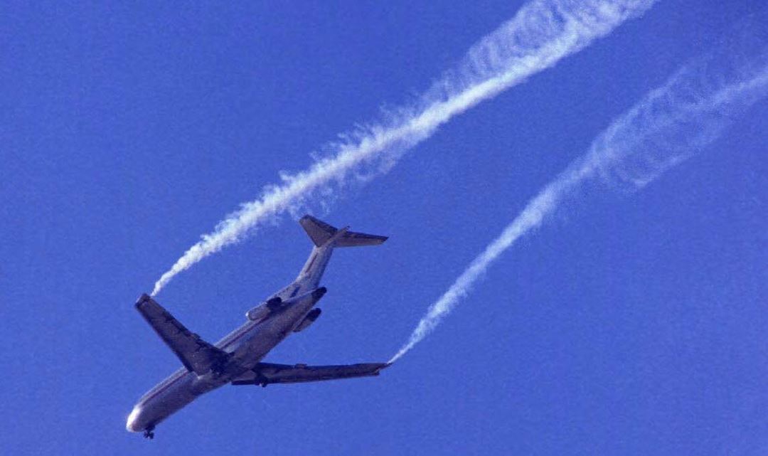
During take-off and landing, strong vortices are produced in the air on both sides of large aircraft because of the pressure difference between the upper and lower sides of the wings.
These so-called “wake vortices” can be dangerous because they are invisible, may be very fast-moving and extend many kilometres behind the aircraft.
Following aircraft can be affected by a powerful, rotating air movement and wake vortices have been the cause of several crashes. For this reason a distance of 11 kilometres must be maintained between aircraft taking off and landing.
Research scientists are now tackling this problem, both from a point of view of safety and in order to achieve a better flow of traffic. The objectives of the important EU programme “SESAR” are to reduce the congestion in European airspace, improve flight punctuality and reduce the impact of air transport on the climate. The programme consists of a total of 16 work packages, and SINTEF research scientists are participating in Work Package 12.2.2, which is studying wake vortices.
More frequent aircraft landings
“These vortices are clearly one of the causes of the delays which afflict air traffic,” says Karstein Sørli, a Senior Research Scientist at SINTEF ICT.
The research team is also working on terrain-induced turbulence, and in collaboration with the Norwegian Meteorological Institute it has initiated a turbulence warning system serving 19 airports in Norway. Svalbard Airport Longyearbyen will become the twentieth in December this year. The SINTEF research team’s many years of R&D effort in this field were decisive in its becoming involved in the SESAR project.
In the SESAR programme, the team is involved in work to develop a system-oriented prototype which will be capable of improving the traffic capacity of airports. Instead of the rigid rules regarding a fixed distance between landing aircraft, the intention is to create a more dynamic, weather-dependent system.
Flight controllers shall be able to assess flight arrivals on the basis of local conditions such as winds crossing airport runways. Under crosswind conditions wake vortices from an aircraft which has just landed will dissipate rapidly and will therefore not present a danger. Hence the next aircraft can land sooner.
Mathematical models
“Wake vortices are affected by, among other things, “wind shear” and turbulence in the airspace near the airport,” says Karstein Sørli. “We use mathematical methods to simulate the way air currents behave in calm and rough weather, and emphasise the importance of being able to predict turbulence under given weather conditions and the influence of terrain and buildings in the vicinity of airport runways.”
The Norwegian research scientists are collaborating with, among others, MeteoFrance, the French national meteorological institute. The institute produces large-scale descriptions of the atmosphere (of approximately 1 km in horizontal extent), while SINTEF’s researchers can provide more detailed descriptions of the conditions – down to a scale of one metre.
“We literally break down the phenomenon to a smaller spatial scale, but depend on input from MeteoFrance,” Sørli explains. “The turbulence forecast produced by our model is then used as the input for modelling wake vortices. The models predict how the vortices are transported and dissipate in given situations. It is clearly important to monitor the flight corridors in the vicinity of airports.”
Interaction between measured data and models
The test locations being studied are Charles de Gaulle Airport in Paris and Frankfurt Airport. Here, comprehensive measurement campaigns are being carried out using different types of equipment such as radar and LIDAR laser technology.
The interplay between the measured data describing the current situation and the research scientists’ mathematical models forms the essence of the prototype which is being developed by the project.
The Thales group has overall responsibility for both the measurement campaigns and the project. Other participants are Indra, DFS and EUROCONTROL. The project will run until 2016.
Åse Dragland

