
SWIM
Software for static modeling and prediction of surface water and urban flooding based on analysis of topography/terrain.

Intense rainfall can cause water to accumulate in depressions and find new routes through built-up areas. Terrain, buildings and other obstacles influence where water flows, while infiltration and drainage affect how much remains on the surface. Computational tools help investigate these relationships and assess the consequences of different measures.
We work with municipalities, consultants, developers and technology providers to:
Contact our Applied Computational Science research group to discuss an analysis task, a development project or the need for new models and tools.
SWIM – Surface Water Integrated Modeling is our open-source software for terrain-based surface water analysis. It identifies catchments, drainage paths and depressions, and describes how areas of accumulated water connect as water levels rise and depressions overflow.
The methods are computationally inexpensive and support interactive exploration of large terrain areas. They make it possible to compare alternatives and investigate how buildings, obstacles, drainage and terrain modifications affect flow paths.
SWIM also includes simplified infiltration and calculations of how water accumulates and drains over time during rainfall events. These calculations use terrain analysis and water balances. When flow velocities and rapid changes in water level are important, dynamic flow models are needed.
We develop numerical methods for the shallow-water equations, which describe how water depth and flow evolve over time. Our work includes efficient computation on graphics processing units (GPUs), wetting and drying, and adaptive mesh refinement where greater detail is required.
We are redeveloping our earlier dam-break and flood simulator in Julia and working towards closer interaction between terrain analysis and dynamic simulation. Fast analyses can provide an overview and identify areas requiring further investigation, while dynamic models can examine the flood event itself. For coastal areas, our experience also includes storm surge modelling through GPU Ocean.
Our work builds on more than twenty years of research into numerical methods for flow. In 2003, we began investigating how graphics cards could be used to solve partial differential equations. Shallow-water equations and dam-break problems provided early examples of combining fast computation with visualisation.
This developed into a collaboration with the National Center for Computational Hydroscience and Engineering (NCCHE) at the University of Mississippi on GPU-accelerated simulation of dam-break flooding. The software was subsequently adapted for urban flooding and licensed to a UK engineering consultancy. The collaboration brought together method development, verification and validation, and transfer into practical use.
A second research line began with algorithms for identifying structural traps for underground CO₂ storage. These use a direct analogy with watershed analysis: water collects in depressions and spills through outlets, whereas CO₂ moves upwards and becomes trapped beneath elevated parts of an impermeable caprock.
Building on these ideas and results from Voldsund's 2017 master's thesis, we adapted the algorithms with Spacemaker for urban surface water analysis. The methods were integrated into the company's planning software through the OptiSite collaboration. This research line continues in SWIM and demonstrates how mathematical ideas can be transferred between application areas.
SWIM is written in Julia and is available with open source code, documentation and examples. The software provides a foundation for further development and integration into other tools.
Development continues through activities including SUrbArea, which develops and tests surface water solutions for sustainable urban development, and builds on work undertaken in SWAMP.
Software for static modeling and prediction of surface water and urban flooding based on analysis of topography/terrain.

Reducing societal risk in a changing climate using nature-based solutions in sustainable urban area development
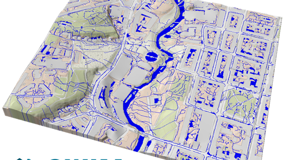
SWAMP aims at developing open-source software for simulation and analysis of surface water caused by flooding and intense rain, and using this simulation software to make demonstrators show casing our experience and expertise.

SINTEF was the research partner in the innovation project OptiSite, led by Spacemaker (now part of Autodesk). The project contributed to developing Spacemaker from a start-up idea to an established product with international presence.