SUrbArea
Work packages
WP1 Risk management and overall valuation assessment
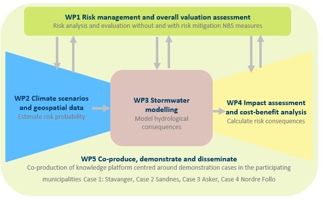
SUrbArea focuses on assessing risks related to stormwater events in urban areas. The risk assessment is based on methodology provided in Norwegian standards and follows a "bow-tie" model, requiring input from the other work packages in an iterative process. The risk assessment begins by describing the overall risk landscape for flooding in work package 1, while work packages 2 and 3 assess the likelihood of and where the floods will occur, respectively. Subsequently, work package 4 will evaluate the societal costs associated with these floods. All information is collected and assessed in work package 1, which also proposes measures to reduce the risk. The measures will consist of various nature-based solutions installed at different locations in the area being assessed for risk. The societal benefits of these measures will be compared against other potential uses of the areas. The process is then repeated with calculations of new consequences and assessments.
WP2 Climate scenarios and geospatial data
Work package 2 consists of two main parts. The first part is to improve the national dataset on waterways by creating new drainage lines from the digital elevation model and adding more information, such as culverts. This improvement is important for understanding the complete picture and will provide more accurate stormwater modeling. The second part involves creating national and specific scenarios from high-resolution climate simulations based on various risk levels and user needs. In urban areas, we will focus on long rainfall periods followed by heavy precipitation to understand uncertainty related to prior weather conditions. Additionally, the work package will include the use of a so-called "storyline" approach to complement scenario thinking. These climate scenarios will provide data tailored to users and to stormwater modeling in work package 3.
WP3 Stormwater modeling
SUrbArea uses the open-source software SWIM developed by SINTEF Digital for stormwater modeling. SWIM employs terrain-based algorithms for efficient computation and visualization of water transport processes. The analyses are fast, enabling interactive workflows, uncertainty estimation, and data calibration. The main focus of the project is on nature-based solutions and how these can be integrated into the modeling. Usability and visualization will also be improved for easier interpretation of data for non-experts, especially in urban planning.
WP4 Impact assessment and cost-benefit analysis
SUrbArea will calculate both direct damage costs, indirect market costs, and non-market effects to assess the societal consequences of floods and the impact of measures. To calculate direct damage costs, we will use insurance claims data and reconstruction costs, while for indirect market costs, we will use Menon's ITEM model for selected companies. The non-market effects will be examined through a resident survey in the two regions involved in the project (Stavanger/Sandes and Asker/Nordre Follo).
WP5 Co-produce, demonstrate and disseminate
This work package will organize the collaboration, demonstration, and dissemination activities in the project. Six full-day workshops are planned where the partnership will discuss plans and results. Central to the project are also the four cases that will be established, one in each municipality, to develop and demonstrate tools related to the risk assessment.
